Trail Mountain bike Le Mesnil-Guillaume - Randonnée VTT du Mesnil Guillaume le 30/05/2010 23 km - Photo

Randonnée VTT du Mesnil Guillaume le 30/05/2010 23 km

 tracegps
tracegps

User

© OpenStreetMap contributors
Length
Length
22 km
Max alt
Max alt
174 m
Uphill gradient
Uphill gradient
393 m
Km-Effort
Km-Effort  
27 km
Min alt
Min alt
52 m
Downhill gradient
Downhill gradient
394 m
Boucle
Boucle
Yes
Creation date :
2014-12-10 00:00:00.0
Updated on :
2014-12-10 00:00:00.0

(1 Reviews)

Mountain bike
Mountain bike
2h00
Difficulty : Difficult

Scan this QR Code to open this trail in the SityTrail application

FREE GPS app for hiking

Logo SityTrail SityTrail

IGN / Geographical institutes

Download SityTrail from the App Store Download SityTrail from Google Play

Logo SityTrail SityTrail World

The world is yours!

Download SityTrail from the App Store Download SityTrail from Google Play Download SityTrail on Huawei AppGallery

About

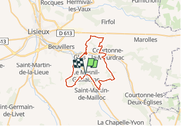
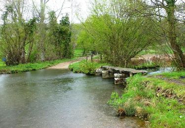
Trail Mountain bike of 22 km to be discovered at Normandy, Calvados, Le Mesnil-Guillaume. This trail is proposed by tracegps.

Description

Très belle randonnée, au départ petite cote en montée, suivie d'une partie roulante et rapide, un vrai plaisir. Puis passage dans une forêt très technique et roulante en même temps. Ensuite descente vers Courtonne la Meudrac, puis longue montée difficile mais faisable on Bike. Ensuite un peu de route et de chemin rapide pour enfin accéder à une descente d'enfer, longue, très rapide (55 km/h) avec des virages appuis, on a envie de la refaire plusieurs fois. Ensuite passage dans un petit tunnel sous la ligne de chemin de fer, puis traversée de Glos pour attaquer une longue montée pour enfin redescendre vers Le Mesnil Guillaume par des descentes tantôt rapides tantôt techniques. Bonne rando, au plaisir !

Elevation profile

Positioning

Country:
France
Region :
Normandy
Department/Province :
Calvados
Municipality :
Le Mesnil-Guillaume
Location:
Unknown
Start:(UTM)
302258 ; 5442947 (31U) N.

Comments

Please log in to post a review or rate the element


Trails nearby

Trail Walking Glos - Au tour. De GLOS - Photo
Walking
pauldurand

Walking

Glos, Normandy, Calvados, France
9 km | 10.9 km-effort
3h 20min
Yes
Trail Walking Prêtreville - Autour de Prêtreville - Photo
Walking
tracegps

Walking

Medium
Prêtreville, Normandy, Calvados, France
11.1 km | 12.8 km-effort
2h 15min
Yes
Trail Mountain bike Glos - Autour de Glos - Photo
Mountain bike
tracegps

Mountain bike

Difficult
Glos, Normandy, Calvados, France
39 km | 50 km-effort
2h 30min
Yes
Trail Walking Lisieux - Autour de la Basilique de Lisieux - Photo
Walking
tracegps

Walking

Difficult
Lisieux, Normandy, Calvados, France
18.7 km | 23 km-effort
4h 30min
Yes
Trail Walking Valorbiquet - Autour de l'Orbiquet - La Chapelle Yvon - Photo
Walking
tracegps

Walking

Medium
Valorbiquet, Normandy, Calvados, France
13.8 km | 18.2 km-effort
3h 0min
Yes
Trail Walking Valorbiquet - 2023 03 19 St Cyr par chemin du Val - Photo
Walking
pauldurand

Walking

Valorbiquet, Normandy, Calvados, France
8.9 km | 11.5 km-effort
3h 16min
Yes
Trail Walking Valorbiquet - St Julien de mailloc - Photo
Walking
werth

Walking

Medium
Valorbiquet, Normandy, Calvados, France
7.9 km | 10.2 km-effort
2h 23min
Yes
Trail Walking Valorbiquet - La Chapelle Yvon  - Photo
Walking
Eve - Line

Walking

Easy
Valorbiquet, Normandy, Calvados, France
13.4 km | 15.5 km-effort
2h 45min
Yes
Trail Walking Lisieux - Gare de Lisieux/St Cyr du Ronceray  - Photo
Walking
Eve - Line

Walking

Easy
Lisieux, Normandy, Calvados, France
16.4 km | 18.6 km-effort
3h 19min
No


Close
My subscriptions